
Aureum
Satellite intelligence for investors to track ports, tankers and datacentres
0points
Details
Launched
November 4, 2026
Category
SaaS & B2B
Pricing
Freemium
Tags
ai-business-data-analysisanalyticsapi-&-datamonitoringtracking
About Aureum
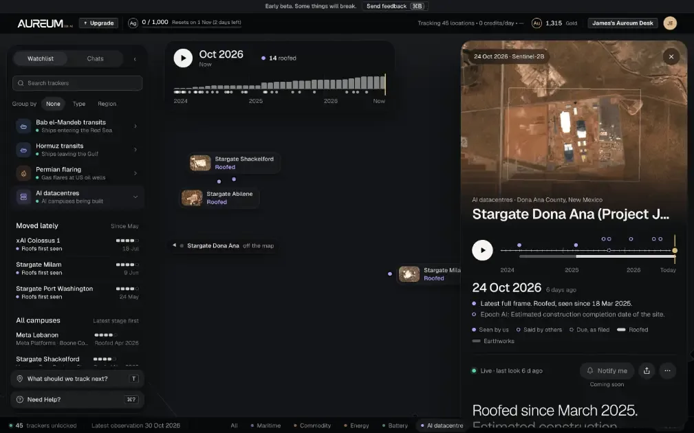
Aureum provides satellite-powered intelligence for individual investors and traders. Query geographic locations and assets to gain actionable market insights. The platform tracks real-time data from ports, tankers, and datacentres displayed on custom-built monitoring boards.
Designed for investors seeking alternative data sources, Aureum helps identify market trends through satellite imagery and infrastructure monitoring. Currently available in beta and free to join.
What Aureum does
Aureum is an AI satellite intelligence platform for individual investors who follow the physical economy. It watches ports, ships, mines, industrial sites, and datacentres, turning satellite observations and other data into Track boards and plain-English answers. The product helps users check measured activity—such as ship counts, stockpile footprints, and corridor traffic—instead of relying only on stale maps, headlines, or specialist tools to assess what is happening at a site.
Users choose a port, stockpile, plant, shipping lane, or datacentre to follow, then review Track boards with readings updated from satellite imagery. To investigate a site, they can ask Aureum a question and receive imagery alongside a written answer. Data sources vary by tracker: shipping combines AIS transponder signals with radar-satellite counts, while ports and mines use optical imagery and, where needed, industry surveys. Trackers show their last update, and older readings carry a stale badge.
Aureum is for individual investors, day traders, and analysts interested in commodities, shipping, energy, or datacentres. The page describes it as a way to check activity at ports, mines, plants, and campuses before relying on market headlines. It handles the satellite sensors, imagery, and analysis behind the scenes, so users do not need satellite expertise or a GIS team. Beta members can request coverage for additional facilities.
Based on aureum-eo.ai, read on Nov 4, 2026.
Key features
- Satellite imagery analysis for ports and industrial sites
- Track boards for ships, congestion, and stock levels
- Radar-based ship counts through cloud and darkness
- Plain-English answers about sites
- Combines satellite, ship-transponder, and industry data
What people use Aureum for
- 01Monitor port congestion and ship activity
- 02Check stockpiles and industrial site footprints
- 03Investigate rumours about plants or datacentres
- 04Track activity along shipping corridors
- 05Review measured activity before trading
More in SaaS & B2B
Browse all SaaS & B2B TanStarter
The complete TanStack Start boilerplate for building profitable SaaS, packed with AI
 SubmitStorm
Directory submission service for startups, SaaS and AI tools: we submit your product by hand
 MikeSullyTools
Built for Creators, Powered by AI
 Peregrine OS
Pre-call intel and daily signal feeds for agency new business.
 Postfleet
Give your agent an inbox it can trust.
 MijnEvent
Verkoop tickets. Zonder gedoe.